Shacktown Falls, North Carolina

As you head further west in North Carolina, you start to find more and more waterfalls. The further east you go in North Carolina, the less likely you are to find waterfalls as the land flattens considerably. As we arrived in Greensboro, I wondered if there were any waterfalls nearby. If you drew a line between Greensboro and Charlotte, that would create a very natural boundary of waterfalls versus no waterfalls in the state. And the closer we are to that boundary, as we were in Greensboro, I wasn’t thinking there’d be many.

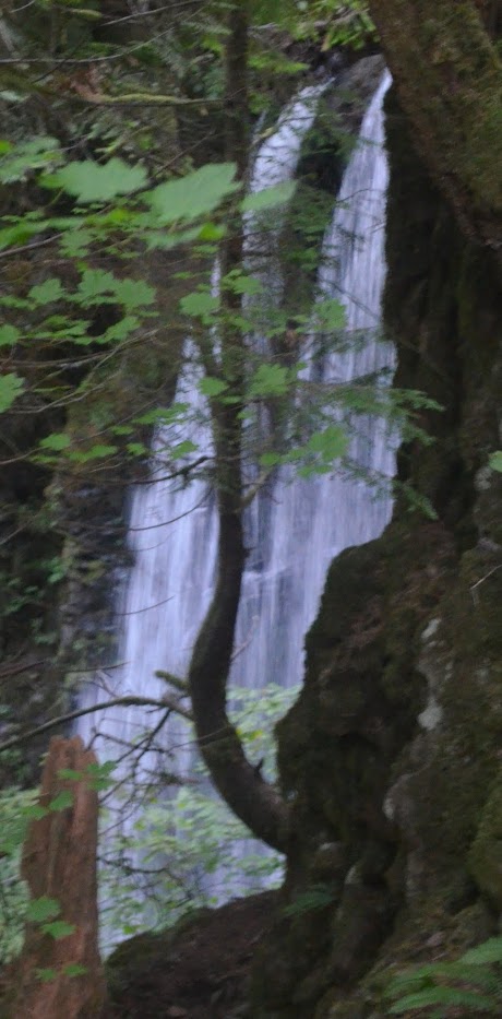
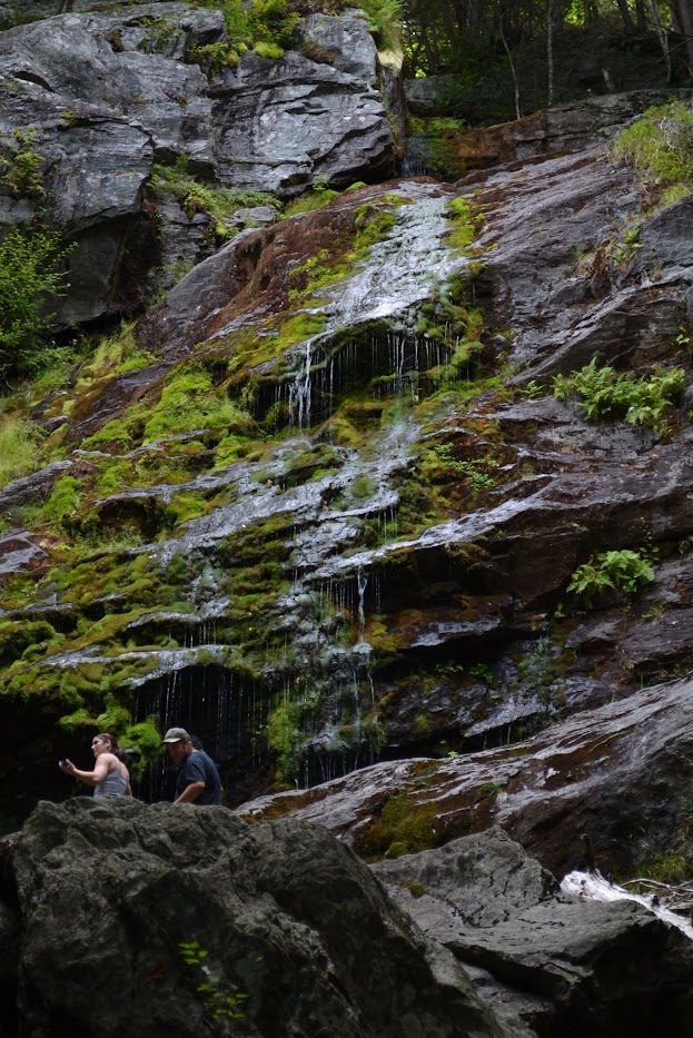
About 15 miles west of Winston-Salem, that’s where you can find one of the first waterfalls near that boundary, Shacktown Falls. Shacktown Falls can be found rather easily in Shore-Styers Mill Park, which is found in the four way stop which is Shacktown. Shacktown Falls is a rather small waterfall at only 12′ tall, but it’s also rather wide! The benefit of the falls is that they’re close to a major area even though there aren’t many others around here. And the falls are very pretty. If you want a retreat to nature but don’t want to go far or on a long hike, Shacktown Falls may be the choice for you.

Directions:

  1. From Winston-Salem, you can head west on US-421.
  2. Shacktown is near Yadkinville, both of which are off of US-421. To get to Shacktown, take exit 253 on US-421. You’ll exit onto Old Stage Road (Road 1733).
  3. Turn right onto Old Stage Road. In under 1000′, you’ll come to an intersection with Shacktown Road (Road 1146).
  4. Turn left on Shacktown Road. At 0.3 miles, you’ll turn right onto Styers Mill Road (Road 1510).
  5. In 0.5 miles, you’ll reach Shore-Styers Mill Park on your left. The falls are a very short distance from the parking area.

Accessibility: 10/10 (easy)
Height: 12′
Length of Hike: 0.1 mile round-trip

Shacktown Falls in November 2023

Where in the World is Shacktown Falls?

Cascade de Baoussous, France

This is a waterfall in Ceret, France. it is about 20 feet tall.
Cascade de Baoussos in January 2024

Today, I set out to find my first waterfall in France. I’m posting about this one because I don’t want to forget how to get there, and I figured my directions might help others. You see…we didn’t notice one thing and that led us into some woods that really didn’t lead anywhere. It wasn’t until we were about to give up that we noticed there was a trail literally feet from us that was probably the correct trail. So here’s some tips and tricks to find this beautiful waterfall in the charming town of Céret.

You might be able to park in the neighborhood near the start of the trail, or you can also park a bit further away. We were already parked near the stadium (Stade Municipal). So we walked east along Avenue d’Espagne. You then turn right onto Rue de la Cascade, right on Rue de l’Enclos, and then right on to Rue de Baoussous. Rue de Baoussos actually veers downhill at a triangle in the road, and you want to follow this downhill, as shown in the photo of the map. It will pass by a small aqueduct.

The path on the streets that leads to the trail

You want to go downhill instead of going a bit uphill. Once you go downhill, there is a sign for the “Cascades”. We made the mistake of thinking the wide road was the path we should follow, though it quickly becomes apparent that’s not the correct option. There is an arrow on this sign that points to the right. If you look, you’ll see there’s a narrower path to the right. There are green arrows. Follow these green arrows, though they occasionally are red. This is the correct path.

The path winds around for a bit, passing by a few houses and then a bit uphill and downhill, though nothing too wild. You’ll pass a smaller cascade and then you’ll cross the river. There was a green arrow that pointed left, but it was clear that we should follow the trail to the right that hugs the river. This leads to the Cascade. There was a bit of boulder jumping involved to get a good view of the falls. There has been a drought in this area of France and Spain (in 2023-2024), but luckily there was water flowing on this falls! It was a really fun waterfall to find, especially since we had almost given up on finding it.

Directions:

  1. The directions are spelled out above and with the photo of the map. I think this will hopefully help others find the falls. We got a bit confused and ended up in some thickets that didn’t lead anywhere.

Accessibility: 8/10 (easy/moderate)
Height: 20′
Length of Hike: 1 mile round-trip

Where in the World is Cascade de Baoussous?

Ecola Falls, Oregon

Ecola Falls in September 2015

Ecola Falls is the the third waterfall above Multnomah Falls. Dutchman Falls and Weisendanger Falls are the other two falls. The hike is one of the more strenuous hikes I’ve ever done, even though it’s not terribly long.

Consider that Multnomah Falls is 620′ tall. To get upstream of Multnomah Falls, you’ve got to traverse that height. I’m no rock climber, so there’s definitely a way to get to the falls, but it’s 620′ over a short 1 mile (if that much). I attempted it in 2009 when I first visited the Columbia River Gorge, and gave up about 2/3 of the way up. I had already visited many other waterfalls that day and was too worn out. In 2015, I attempted the hike again and succeeded.

Once you get past that portion of the hike, it’s not a terrible additional portion of the hike (that I remember). There is still some uphill climb, but not as much as getting to the crest of the falls. To get to Ecola Falls and back down, it’s about 2.8 miles round-trip. Ecola Falls is the hardest to view as it is blocked by many trees. So I would probably turn around before reaching Ecola Falls unless I really wanted to add this to a waterfall list (like I did).

I know there were some wildfires in the Columbia River Gorge in 2017, very close to Multnomah Falls, that closed some access to the falls for a period of time. That is now open. But it is still an extremely visited waterfall, and from the US Forest Service website, there is now a reservation system for the summer months. I would include a link, but often the links expire, and it wasn’t difficult to find information the reservation system.

Directions:

  1. Take the exit off of I-84 toward the Columbia River Gorge Scenic Trail, and follow the road. It’s pretty hard to miss Multnomah Falls. The parking for the falls is actually right in the middle of the road.
  2. From the parking area, start heading toward the bridge that crosses Multnomah Creek. This is a uphill climb to begin.
  3. After crossing the bridge, you’ll have a 1 mile uphill hike. This is the part that’s tough. Once you reach switchback 9, you’ll head downhill.
  4. After reaching that switchback and heading downhill, you’ll reach a split. If you head right (indicated by a sign), you’ll reach the Multnomah Falls upper viewpoint. If you head left along trail 441, that will lead toward Weisendanger Falls. Even if you miss this first left, there’s a left later on.
  5. It’s about 0.4 miles further from the switchback to Weisendanger Falls. If you continue uphill beyond that, you’ll reach Ecola Falls.

Accessibility: 2/10 (strenuous)
Height: 55′
Length of Hike: 2.8 miles round-trip

Where in the World is Ecola Falls?

Rustic Falls, Wyoming

Rustic Falls in June 2014

There are so many beautiful waterfalls in Yellowstone National Park, in addition to all of the other amazing scenery and geological features. I’m ready to go back again and explore more! It’s been about 10 years since I’ve visited, so maybe next year is the right time to return.

Some of the waterfalls in the park are very widely known, mainly the namesake Lower Yellowstone Falls and Upper Yellowstone Falls. They’re relatively easy to visit, as are many of the others. None of them required a long hike that I can remember. A number of them are roadside waterfalls, and Rustic Falls is one of those roadside stops that make it so worth it to visit the park.

Rustic Falls is listed as being 47′ tall. That might be the top portion of the falls with some additional cascades below the falls. It’s a wider waterfall than some, so it seems like a bigger waterfall to me.

The best time to visit the park is in the summer months, at least for waterfalls and limited snow. Even when I visited in June 2014, it was rather cold and rainy, though the closer I got to Montana, the warmer it became.

Directions:

  1. There is a northern entrance to the park near the Montana/Wyoming border. The entrance is along US-89 and then heads into Mammoth. Mammoth is where you’ll find the Mammoth Hot Springs.
  2. To find Rustic Falls, you want to head south along US-89. About 5 miles south of Mammoth, you’ll find a parking area for the falls. If I remember correctly, there may be a sign but not much else. You’ll still have great views of the falls.

Accessibility: 10/10 (easy)
Height: 47′
Distance of Hike: roadside

Where in the World is Rustic Falls?

Tews Falls, Ontario

Tews Falls in July 2019

So many waterfalls in Ontario, so many yet to explore. Tews Falls is one of the really beautiful waterfalls in the Hamilton area. Of the four waterfalls I saw in Hamilton in 2019, this was probably my favorite. But again, there are many more waterfalls in the area. I think we chose Tews Falls because there’s also Webster Falls in the same park.

I’ve found after following some Facebook waterfall pages that some of the falls in Hamilton can be a bit confusing about when best to visit, or if you can visit, or how to best visit. Tews Falls was on the list of easier to visit falls. And it’s definitely an easy falls to visit. It’s a very short hike from the parking area to the viewpoint of the falls.

The falls are 135′ tall or so, and they’re very impressive. The viewpoint allows for a full view of the falls, which was more difficult at Webster Falls. I don’t think there was a trail to the base of the falls, but I don’t remember perfectly. And even if there is an unofficial trail to the base of the falls, I would strongly recommend against it. I know this is what has bothered Hamiltonians…some of these falls do not have access to the bases of the falls, and this leads to rescues after someone invariably falls. It also leads to these waterfalls being closed to the public, so let’s keep it simple and stay on the designated trails. The views are more than acceptable.

Directions:

  1. Directions:
  2. There are a number of different paths you could take to get to the Spencer Gorge Conservation Area and Webster Falls. I would suggest having the map on your car/smartphone direct you to Webster Falls.
  3. There are separate parking areas for Tews Falls and Webster Falls. Tews Falls is found off of Harvest Road.

Accessibility: 10/10 (easy)
Height: 135′
Distance of Hike: 0.1 miles round trip

Where in the World is Tews Falls?

Fonferek Falls, Wisconsin

Fonferek Falls in June 2022

There are a few waterfalls very close to Green Bay. One is Wequiock Falls, which is northeast of Green Bay. A bit southeast of the city is Fonferek Falls. Wequiock Falls is closer to the lake, so to me it had more of that type of vibe, playful with swings above the falls. Fonferek Falls has a more country feel.

The trail to Fonferek Falls starts at a house with a barn, though don’t trespass! As you walk along, the country feel builds. Even though there wasn’t much water flowing at the falls, there’s definitely some farm runoff that flows into the creek because there’s a farm smell. Not bad, just adds to the vibe!

There are multiple views of the falls. When you first get to the falls, it’s a good view, but it’s fun to explore more. I would guess that at times where there’s a lot of water flowing, the options may be more limited. When we visited, we were able to cross the creek without much difficulty and check out the left side of the falls. And even there, there are more options to explore. We found some walking paths that headed downhill to the base of the falls and were able to get that view also. The picture here is from the base of the falls. The whole top of the falls is very beautiful, but in those pictures, it’s hard to tell where the waterfall is. Fonferek Falls might be best to visit after a good rainfall or after the snow starts melting.

Directions:

  1. Fonferek Falls is not far from I-43. Whether heading north or south on I-43, you can take exit 178.
  2. From exit 178, turn south on Elm View Road. Drive along Elm View Road, which then veers to the right and turns into Dutchman Road.
  3. Continue along Dutchman Road (County Road MM) until you reach the sign for Fonferek’s Glen Brown County Park. If you’re headed west, the road will be on your right.
  4. The turn is for Memory Lane, which quickly dead ends at the house/barn and trailhead. Respect the private property here. Follow only the trails that lead to the falls.

Accessibility: 8/10 (easy/moderate)
Height: 30′
Distance of Hike: 0.2 miles round trip

Where in the World is Fonferek Falls?

Tunnel Falls, Alberta

Tunnel Falls in August 2014

I’ve written about Johnston Canyon before, but I’ll reiterate this again…Johnston Canyon is really beautiful. You can find it in Banff National Park, and it’s really a worthwhile hike, even if you’re not interested in waterfalls. The canyon is really amazing and the water is so blue.

There are a number of distinct waterfalls that are large enough to be named in the canyon. I have six or so named falls. There are the Lower Johnston Canyon Falls, and then three interestingly named falls in between that and Upper Johnston Canyon Falls. Cavern Falls, Stella Falls, and Tunnel Falls are the three falls. Not that they’re wildly unique names, but I guess these three just needed more interesting names than Johnston Canyon Falls or something of that sort.

Tunnel Falls by itself would be a worthwhile waterfall to visit. With the other impressive waterfalls in the canyon, it’s a must see in my opinion.

Directions:

  1. This isn’t a particularly difficult set of waterfalls to find, with one minor hitch. The trail head is along of the Bow Valley Parkway (Highway 1A). If you’re driving along the Transcanadian Highway 1, there are limited entrances/connections onto 1A. In order to find the falls, you can either enter onto 1A a few miles after leaving Banff. You will be heading west if you take this exit, and the trail head will be on your right after driving for a while. (You can also exit at the junction of Transcanadian Highway 1 and Alberta 93. Instead of heading south, though, head north for a short distance. Then turn right and drive for 6.4 km. The parking area will be on your left.)
  2. I mention a parking area, but as I said, that parking area was completely full. There were at least a hundred or so cars (possibly more) parked on the sides of 1A, so that’s where I parked. It added a little bit longer to the walk, but it wasn’t much.

Accessibility: 8/10 (easy/moderate)
Height: 25′
Distance of Hike: 1.7 miles round trip

Where in the World is Tunnel Falls?

Lower Race Brook Falls, Massachusetts

Lower Race Brook Falls in August 2012

I’ve mentioned before that I don’t always remember specific waterfalls. I should probably write about the waterfalls immediately after visiting the falls, but sometimes that would mean writing about many waterfalls at once. I also like to write about different falls from different states and countries to give a bit of flavor.

A few of the waterfalls in New England leave a distinct memory, but some of these falls consistently fall into the less memorable category (to me, at least). I know I visited the Lower Race Brook Falls at the same time as the more widely known and popular Bash Bish Falls. There are five separate falls on Race Brook, but I only visited the first falls. The hike to visit all of the falls is over 3 miles round-trip, so I’m guessing I was worn out after finding the first falls, and turned around from there!

The hike to the Lower Falls is about 1.3 miles round-trip. I don’t wildly remember the hike, and I didn’t consistently categorize the difficulty of hikes until later so I didn’t forget when I’m writing about them 10 years later! I rated it this as a moderate difficulty hike, which could be based on some other sources. The whole hike is rated as a more moderate or strenuous hike.

I’ve seen pictures of some of the falls on Race Brook with much higher water levels. When I visited in August 2012, there wasn’t a whole lot of water flowing. The falls are in Berkshire County (The Berkshires), and the area was really beautiful. So even though I wasn’t wildly impressed with the flow of the falls, the atmosphere was really wonderful.

Directions:

  1. The start of the trail is found along MA-41 in between the city of Great Barrington and the Connecticut border.
  2. MA-41 and MA-23 are the same road in Great Barrington, but near the village of South Egremont, MA-23 continues west and MA-41 continues south. You want to continue along MA-41.
  3. If heading south, continue from South Egremont just over 5 miles. The parking area for the Race Brook Falls Trailhead is on the right. If you go to far, you’ll reach the Race Brook Lodge.
  4. As mentioned, at the trailhead, you can do a 1.3 mile round-trip hike to see the Lower Falls, or you can do the whole hike at about 3 miles round-trip.

Accessibility: 6/10 (moderate)
Height: ~100′
Length of Hike: 1.3 miles round-trip

Where in the World is Lower Race Brook Falls?

Daisy Low Falls, Indiana

Daisy Low Falls in May 2017

There are waterfalls in Indiana, and while smaller, some of them can be very fun to visit. In the Kokiwanee Nature Preserve, there are three falls. Check out Kissing Falls for more info about where I parked and started along the trail.

Daisy Low Falls is the second waterfall I encountered, and I was able to capture some good pictures of this waterfall. Frog Falls was the most difficult to capture. I somehow knew to look for Daisy Low Falls, even though it doesn’t show up on the current Kokiwanee ACRES Land Trust map. ACRES takes care of the lands here. Their map shows Frog Falls, and I know that Daisy Low Falls was in between Kissing and Frog Falls, Kissing being the first waterfall I found along the trail.

There’s a trail that follows the Salamonie River, and that’s the one that I took to find Daisy Low Falls. ACRES land trust still rates this as a more difficult hike, though I believe they’re referring to the a much larger loop you can take. I did not find it to be a difficult hike or trail to the falls, though I remember doing some uphill hiking on one of the trails to find Frog Falls. The one thing I would caution: It was very muddy on the day I arrived at the preserve. It had rained the day before, so I had to be careful not to slip, but that was the main issue. I don’t remember climbing much uphill.

Directions:

  1. This is an instance where there’s not an obvious starting point. You can approach from multiple directions. It’s in between Wabash and Huntington south of US-24.
  2. The official entrance to the park is off of E 50 S (GPS at 5825 E 50 S, Lagro, IN 46941). I instead went to the intersection of E 50 S and Stone Road, and went south on Stone Road, turned right onto the road that led to the Salamonie River Boat Launch (can’t remember if there was a more specific name).
  3. At the end of this road, there’s a parking area. The trail to the falls starts at the end of the parking area (read above).

Accessibility: 9/10 (easy)
Height: 10′
Length of Hike: 0.3 miles round-trip

Where in the World is Daisy Low Falls?

Sgwd Isaf Clun-Gwyn (Lower Fall of the White Meadow), Wales

The Four Falls Trail in Brecon Beacons National Park is a really beautiful hike to see…four waterfalls! The first waterfall you see is Sgwd Clun Gwyn (Fall of the White Meadow). It’s the easiest of the four falls to visit. After Sgwd Clun Gwyn, it becomes far more strenuous to see the other three falls.

Sgwd Isaf Clun-Gwyn is along the same river, hence the “Lower” Fall of the White Meadow in English. And to get to the lower falls, you’ve got to head downhill. And that’s uphill and downhill for the other two falls also. While a hike to two falls might be moderate, when you add two other falls on top of these two, it becomes a rather strenuous hike, in my opinion.

The falls are very beautiful, to say the least. Sgwd Isaf Clun-Gwyn might be the most complicated of the falls. Depending on the source, the falls are listed at 20-30 meters (~60-90 feet). At the “viewpoint” for this falls, the viewpoint being in the middle of the river, you can’t see all of the drops. You can see some smaller drops very clearly and can also get a glimpse of some of the larger drops. But I couldn’t get a glimpse of the whole shebang. There are four or five drops that compose Sgwd Isaf Clun-Gwyn, so some people might classify this as four or five separate waterfalls.

Directions:

  1. Main route A465 will likely be your starting point. Take the exit to Glynneath, which will put you on A4109.
  2. From A4109, you’ll very quickly after turn right onto B4242, and then left onto Pontneathvaughan Road. You’ll continue on this road for about 5 miles.
  3. Google Maps tried to direct us down a very narrow country road (which didn’t have any signage for the falls). I continued until I saw the actual sign for the waterfalls trail, and turned right. It was still a very narrow road but it led us directly to the Cwm Porth Car Park. (You can also start at the Gwaun Hepste Car Park, though it does lead you down some different trails.)
  4. There is a £4 fee to park, and then you can start the hike to the falls.

Accessibility: 3/10 (moderate/strenuous for whole set)
Height: 40′
Length of Hike: 5.5 miles for the whole set

Sgwd Isaf Clun-Gwyn in June 2018 with some people in wet suits (not sure what exactly they were doing) for reference

Where in the World is Sgwd Isaf Clun-Gwyn?